
The use of spatial analysis and population datasets for public health interventions is witnessing widespread adoption. And why not, as the benefits are immense. Public health departments and NGOs get a better understanding of spatial epidemiology through these measures.
It helps them in improving the control and surveillance strategies. There are several types of interventions taken up through the use of GeoSpatial AI for public health. This article walks you through all of that, including the use cases.

Table of Contents
What is the Spatial Analysis and How is It Used in Public Health Intervention?
Developing and underdeveloped countries often suffer from a lack of financial and human resources in healthcare. The problem further gets compounded due to limited infrastructure and discrimination in available resources. A lack of transparency, accountability, and community participation also affects capacity building.
The response measures take a hit. It can either be the response to the outbreak of an infectious disease or post-disaster relief measures. The use of advanced tools like spatial analytics is thus vital. The use cases are applicable in response measures towards healthcare or even disaster relief.
Spatial analysis for public health tools like human population density maps has a wide-ranging use in the healthcare industry. These maps help researchers and government agencies to check the impact of climate change and urbanization on people.
The Data for Good initiative of Facebook has population density mapping as one of its key components. Facebook is working towards creating the most accurate population datasets globally. They have partnered with the Center for International Earth Science Information Network (CIESIN) at Columbia University. The work involves locating buildings from mapping services that are available for public use.
The Spatial Computing team at Facebook is training pattern-recognizing algorithms to map populations. It helps them in locating and identifying buildings through satellite imagery data available from Maxar. The algorithms get trained to study different landscapes for accurate modeling.
CIESIN uses the data from Facebook’s analysis and combines it with the Census data. It helps them in creating population estimates that further get used in the structures of satellite imagery.
What Are the Challenges That the Public Health Sector Faces?
For most developing countries, the healthcare system has always remained a significant challenge.
- A high population is the most important factor contributing to the challenges of healthcare institutions.
- The available resources are often in sparse numbers. People fail to get adequate treatment in time.
- The black marketing of medicines and other health care aid also remains rampant.
Besides affecting the healthcare segment, a high population inadvertently decreases the quality of life. Beneficiaries of public welfare schemes often lament the aid not reaching them. Even if it reaches, it often falls short of expectations. AI for non-profits, through population density mapping, plays a vital role in overcoming these challenges.
Government agencies and the development sector players are adopting use cases from spatial data science for their operations. Spatial analytics involves data interpolation, pattern analysis, and predictive modeling. These tools aid in overcoming ground-level challenges comprehensively.
Here are some benefits of using spatial analytics in population density mapping:
- Remote sensing and sampling frames for population sampling
- Spatial data interpolation for environmental exposure analysis
- Optimization algorithms for logistics support
Spatial analysis for public health thus transforms research methods, epistemological paradigms, and programming landscapes in multiple ways. The development sector, whose operations have remained restricted due to geographical limitations, can leverage spatial analytics to prepare better mitigation strategies.
How Spatial Analysis Helps in Solving Public Health Challenges?
We Build Custom Geospatial Solutions to Support Non-Profits & Government
Check Out Our Spatial Analysis Solutions
Government agencies and healthcare institutions are realizing the growing importance of spatial analysis for public health. They have made it a vital part of their response measures. Here are some examples highlighting the use of spatial analysis for public health.
Facebook Data for Good COVID-19 Response
Facebook Data for Good has come up with several tools and initiatives to enable organizations to plan their response measures to the Covid-19 pandemic. They have listed several public and non-public datasets that are handy for researchers and organizations.
Let’s take a look at some of those tools that use spatial analysis for public health.
High Resolution Population Density Mapping
These are global datasets about population data analytics that help identify potential problem areas for the population that remains vulnerable to Covid-19. The maps make use of satellite imagery and census data.
Movement Range Maps
Health experts and researchers get the knowledge of how people are responding to social distancing norms. The data comes from the location of mobile users who wish to show their precise location.
COVID-19 Forecasts
Public health experts and researchers get help for planning and allocation of resources and early outbreak detection. Facebook is using AI to build adaptive models that work with public and non-Facebook data.
Disease Prevention Maps
These help public health organizations in understanding the movement pattern of people to improve response measures. They remain a vital aspect when we consider population health intelligence data. There are four types of disease mapping tools here that make use of cellular data.
Infrastructure Planning and Its Impact
Population density mapping helps in planning and assessing the impact infrastructure investments can have on communities. It is essential for remote areas where healthcare facilities can be abysmal. Global funding agencies for development projects use high-resolution maps and other data of interest to analyze accessibility to services like medical facilities in a particular geography.
This urban population estimation with satellite imagery helps in prioritizing resource allocation based on socio-economic objectives. The planning ensures that people can access medical facilities through roads without any disruptions. The investments also stand to be more effective. It thus improves the overall impact of the program.
Spatial Analysis Solution for Urban Resilience
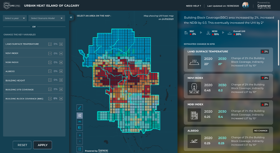
Evergreen is a Canadian non-profit that helps build sustainable, flourishing cities. Under a Microsoft AI for Earth grant, they partnered with us to build an AI-driven 3D data visualization tool to track the effects of climate change.
You can check out the tool and take a free demo. If you want more information about the project, contact us at contact@gramener.com.
The tool is being piloted in the City of Calgary. Currently, it can track, predict, and visualize urban heat islands. The team is planning to expand it to cover other climate-related disasters for making cities resilient.
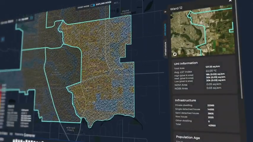
Gramener is helping Evergreen make use of AI, big data, and GeoSpatial analytics to solve these problems.
GeoSpatial for Natural Disaster Recovery
To mitigate the risks of natural disasters, it is essential to understand where people live. Population density mapping helps in identifying areas under threat due to climate change. It becomes possible to target those areas with preparedness measures. The assessment also helps in the planning of better disaster recovery measures.
At Gramener we worked with SEEDS India and Microsoft to build a solution that generates hyper-local risk information to be used for early warnings for impending disasters. Furthermore, the AI-driven model uses high-resolution satellite imagery that is interpreted by the system for identifying the most vulnerable houses to recommend immediate and long-term actions to reduce risk.
SEEDS, utilising the predictive analytics capabilities of the solution, scaled the model to generate heat wave advisories in 2021, supporting 50,000 at-risk families by sharing pre-emptive heatwave warnings recommending cost-effective interventions.
The solution has capabilities to generate targeted advisories to protect vulnerable communities, their valuables, avoid immediate losses, and provide pre-emptive refuge to the people.
Disaster risk management organizations are already using spatial data in several ways to strengthen their response measures. Population density mapping further complements the existing tools to improve the response.
Disease Surveillance and Prediction
Mobile apps enabled with self-diagnosis mechanisms are helping government agencies to manage the Covid-19 crisis effectively. Tracking of symptoms is reducing pressure on healthcare hotlines. It is also giving a Spatio-temporal perspective to understand the pandemic.
Spatial analysis for public health techniques like the use of neural networks and pattern recognition algorithms are helping with the following analyses:
- Social distancing and demographic analysis through the use of spatial data on human mobility
- Overcrowding analysis to ensure hassle-free movement for essential workers
- Supply chain optimization to meet consumer demands in line with existing regulations
- Data visualization to enable a better decision-making
- Sentiment analysis to understand how the pandemic is affecting the behavior of citizens
GeoSpatial for Healthcare Analytics
The location of a patient can have a direct impact on their health. For better clinic site selection and disease prevention, AI for public health assumes a vital role. Healthcare systems can optimize resource allocations for better patient management. Spatial analysis for public health helps in understanding the root cause of wellbeing problems due to location-related factors.
Timely diagnosis is essential but remains one of the challenges for healthcare providers. In case of severe illnesses, each minute is critical for patients as they might need an ICU admission. Delays in getting ICU admission can have a direct impact on the mortality rate.
Machine learning (ML) and neural networks are helping overcome this problem. Data related to patients like health history can help detect vital signs and symptoms even before a doctor diagnoses them. ML algorithms can work on electronic health record (EHR) data. It can help doctors understand different symptoms and remove false positives.
The strong computational abilities of these algorithms remove the complexities around symptoms for better diagnosis and treatment. Medical imaging and convolution neural networks are fast gaining popularity.
The imaging through X-rays, mammograms, and MRI scans are helping in revealing a disease even before the patient shows any symptoms. It is especially true for a disease like cancer, whose early detection is essential to save lives and reduce treatment costs.
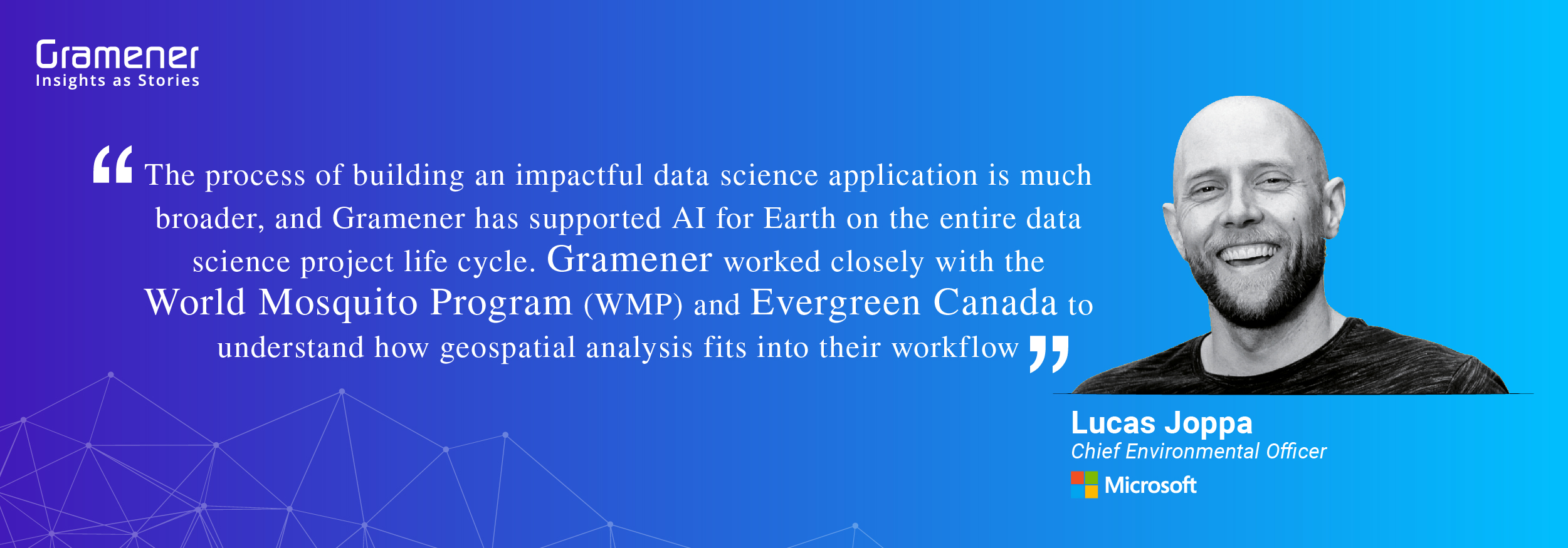
Gramener’s Geospatial AI Model to Map Population Densities for Health Intervention
At Gramener, we partnered with the Microsoft AI for Earth initiative for the World Mosquito Programme (WMP). The initiative aimed at controlling the spread of mosquito-borne diseases and saving lives. We created an AI-powered GeoSpatial analytics solution that uses satellite imagery data.
The GeoSpatial application maps the locations at a granular level. It also uses several data variables like the existing release point records of WMP, weather, community-wise population densities, and much more. The application can identify release points as close as 100 square meters. The global availability of these data points ensures that they remain widely implementable.
The GeoSpatial application is built on Gramex, an in-house low-code platform. The PaaS data science platform uses low-code technology to accelerate the speed of app development. The tool is ideal in building apps that rely heavily on data to generate insights for improved decision-making.
Interested in learning more about the GeoSpatial application and Gramex? Contact us today, and our experts will get in touch shortly.
Contact us for custom built low code data and AI solutions for your business challenges and check out spatial analytics solutions built for our clients, including Fortune 500 companies. Book a free demo right now.