
When the city of Calgary in Canada faced the adverse effects of climate change, the government adopted technology to replan the city structure. With the help of GIS and spatial analysis techniques, they were able to accelerate urban planning with valuable insights from past climate data.
More on that later. Let’s shed some light on what urban planning includes.
Since time immemorial, human beings have undertaken urban planning. Early examples of urban planning include efficient street systems, civic buildings, temples, palaces, water supply, and drainage.
Today, urban planners build high streets like commercial buildings, parks, recreational centers and make them resilient.
Urban resilience is a crucial element in this mix.
Table of Contents

What is Urban Resilience?
Urban Resilience is the capacity of urban systems and their inhabitants to withstand calamities such as climate change effects, pandemics, earthquakes, etc. It involves protecting the most vulnerable community members and making sure that they are not susceptible to natural or man-made disasters.
Urban resilience leads to the ongoing continuity and sustainability of an urban system.
This is the first article in a blog series where we explore how technology solutions are helping create resilient cities, thereby making our world a better place and securing it for our future generations.
What is Urban Planning?
Urban planning is the process of creating plans for administering and regulating metropolitan regions, cities, and towns. It is concerned with the environmental and economic consequences of allocating resources along spatial boundaries in society.
Geographically and historically, the objectives of urban planning have varied considerably. Communities have often undertaken urban planning to respond to inefficiencies resulting from unchecked settlements. Also, the technology advancements have made it possible for better planning of resources.
For example, the use of GIS technology in urban planning prevents the negative impacts of development.
GIS Tools for Urban Planning
Resiliency planning is at the top of the agenda for municipalities worldwide. The need to prepare for hazards caused by climate change is urgent.
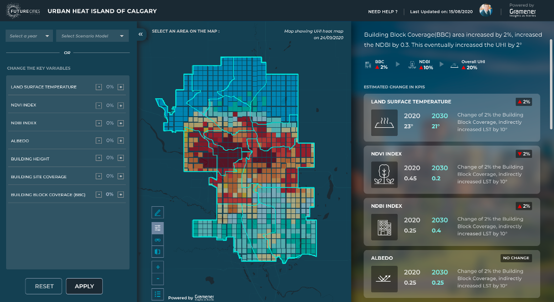
Evergreen, a Canadian non-profit organization, has created the AI for the Resilient City initiative to combat climate change. AI for the Resilient City is a data visualization tool. It is funded by Microsoft’s AI for Earth program and aims to mitigate climate change impact across Canada.
Calgary will be the first city to implement this new tool. By the 2080s, the city’s annual average temperature is expected to rise by up to 5 degrees Celsius, making it more susceptible to climate-related hazards.
AI for the Resilient City will monitor the city’s extreme heat, also known as the Urban Heat Island (UHI) effect. Municipal stakeholders will use this tool to identify areas most affected by UHI. This data will help deploy measures to build resilience to climate change.
Read Now: Check out our latest article, published on Tech Crunch that talks about mitigating UHI effects in cities with AI.
Evergreen’s Partnership With Gramener To Build AI for Resilient City
Evergreen Canada collaborated with Gramener, Microsoft ISV Gold Partner, with experience in building sustainable AI and Data solutions for environmental causes, to develop this technology.
The tool combines key datasets like Census Data, Azure open datasets, Microsoft’s Building Footprints, and NASA’s Landsat Imagery. By consolidating and analyzing data from these sources, the tool aims to provide invaluable insights to Climate Adaptation Teams, Urban Infrastructure Planners, and Municipality Bodies.

Benefits of Using GIS for Urban Planning
Improved Mapping
GIS offers the most powerful visualization tools in mapping. Planners can use it to prepare for service interruptions and map the efficient delivery of utilities.
Using features such as multilayered mapping, municipal planning committees can visualize highly erodible land, high flood frequency, surface water, and prime agricultural land. This information helps stakeholders make well-informed decisions.
Planners can use GIS to have better access to maps, reduce storage cost, better thematic mapping, and improve map currency. GIS for urban planning can deliver superior mapping 90 percent faster.
Strategic Decision Making
GIS is a formalized information system that is computer-based. It can gather and analyze data from multiple sources to deliver insights that help effective decision-making. GIS can help visualize changes in geography over a time period. This can help professionals make well-informed decisions.
GIS makes it easy for decision-makers to understand modeling results by using graphic forms. When used in conjunction with GIS, multi-criteria decision analysis can help with the selection of planning options by providing the necessary technical inputs.
A decision support system (DSS) framework integrates graphics, analytical models, and database management systems to improve decision-making. Experts believe that DSSs such as spatial decision support systems (SDSS) and planning support systems (PSS) will soon be indistinguishable from GIS for urban planning.
Socioeconomic Data Utilization
Socioeconomic data is often lacking and generally limited only to population census data, which is vital to regional and urban planning. The collection of data requires field surveys which are time-consuming and expensive. To store socioeconomic data you can use GIS for urban planning. Environmental planning models that identify areas of development conflict and ecological concern can be created using the socioeconomic data stored in GIS.
Contact Us: We build data & AI solutions for finding actionable insights from climate data, LandSat data, and much more. Check out our spatial analytics solutions and use cases.
Applications of GIS in Urban Planning
Brazil’s Response to the COVID-19 Crisis
The World Health Organization (WHO) declared the Covid-19 Coronavirus a pandemic in March 2020. In June, Brazil had the second-highest number of total cases and total deaths globally.
More than twenty percent of the country’s confirmed cases came from Sao Paulo State. Almost 50 percent of all confirmed cases in Sao Paulo State came from the city of Sao Paulo.
To successfully control the transmission, the authorities urgently wanted to understand the incidence of Covid-19. They conducted a GIS-based spatial modeling analysis of Sao Paulo city’s social and environmental factors.
Using a digital map of Sao Paulo city and the information provided by Sao Paulo State, 18 socio-environmental and demographic variables were identified. The analysis results showed a direct correlation between Covid-19 deaths and factors such as informal urban settlements, the average number of people per household, and population density.
The model explained more than 85 percent of all Covid-19 death incidences, both suspected and confirmed.
Boston Smart City Program
The World Bank estimates that Boston is the eighth most economically vulnerable city to climate change in the world. Built chiefly on wetlands, it is highly susceptible to coastal flooding, subsidizing land, and rising sea levels.
The city has deployed a GIS-based decision support tool to foster green infrastructure development, science-based prioritization, and effective collaboration. Using vulnerable population location and environmental threat data, this technology identifies priority areas for investment in green infrastructure.
A Technical Advisory Team partnered with universities, organizations, and agencies to develop this tool. It identifies multi-jurisdictional and large-scale sites to build innovative infrastructure projects that are climate-specific.
Conclusion
According to the World Cities Report 2020 by the UN Human Settlement Programme, also known as the UN-Habitat, urban areas account for 55% of the world’s population. That number is expected to be 68 percent by 2050.
To prepare for the inevitable effects of climate change and unforeseen future calamities such as a global pandemic, in 2013, The Rockefeller Foundation pioneered the 100 Resilient Cities (100RC) initiative.
Cities that benefited from 100RC could appoint a Chief Resilience Officer, develop a strategy for resilience and access the services of NGO partners and the private sector free of cost. They could also participate in a global knowledge-sharing network through their Chief Resilience Officers (CROs).
From 31st October to 13th November 2021, the United Nations Climate Change Conference, commonly known as the COP26, was held at Glasgow, Scotland, UK. 197 attending members negotiated the Glasgow Climate Pact, the first of its kind to commit to reducing coal use explicitly.
In addition to countries, even global corporations support the fight against climate change. Microsoft commits that they will become carbon negative by 2050. Companies are hiring sustainability officers whose responsibilities are similar to CROs in resilient cities.
Many international businesses have adopted the Triple Bottom Line strategy where, besides financial performance, firms also measure their environment and social impact. Contrary to the standard bottom line, i.e., generating profit, firms are committed to the 3Ps – planet, people, and profit.
Organizations will have to invest in technology solutions such as GIS for urban planning and Geo AI to combat climate change and fend off future pandemics. To meet their carbon neutrality deadlines, companies will require carbon footprint trackers.
In our subsequent articles, we will be discussing the aforementioned technology solutions and how they can help your company manage its carbon footprint and become more environmentally friendly.
Contact us for custom built low code spatial analytics solutions for your business challenges and check out ESG and AI solutions built for our clients, including Fortune 500 companies. Book a free demo right now.

GIS technology’s role in urban planning is fascinating, providing a holistic approach to design and development. The blog effectively highlights the transformative impact of spatial analysis, making it a must-read for anyone interested in the intersection of technology and urban planning. Great insights!